 World
World Austria
 Bulgaria
 Great Britain
 Germany
 Israel
 Spain
Spain Moldova
 Russia
 Romania
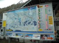
Ski map of Solden
| country/place Austria | |
| city/place Soelden | |
| date | 01/02/2014 |
| geo-coordinates | 46.959699,11.009171 |
| see in galleries | #5# |
| tags | Alps, Austrian Tyrol, ski resorts |
There is an interactive map with the scheme slopes, the air temperature and the operation indicator slopes and lifts. If you look at the photo, you can see half of the slopes and lifts was closed despite the relatively good weather at the bottom. Blame was low clouds, snow and wind.
| file local name | DSCN9781.JPG |
| MIME-type | image/jpeg |
| file format | JPG |
| width/height | 3638x2726 px |
| width/height | 800x600 px |

Keywords: Alps, Austrian Tyrol, ski area, ski map, ski resort