 World
World Austria
 Bulgaria
 Great Britain
 Germany
 Israel
 Spain
Spain Moldova
 Russia
 Romania


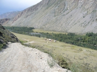
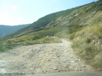
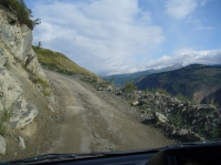
Descent from the mountain pass Katu Yaryk
| country/place Russia | |
| city/place Altay | |
| date | 10/08/2009 |
| geo-coordinates | 50.911239,88.223371 |
| see in galleries | #6# |
| tags | canyons, Chulyshman valley, mountain passes |
Mountain pass Katu-Yaryk - is the rocky dirt road, was built in 1989 at Gornii Altai . This is only way, whcih can allow to get to the south shore of the Teletskoye Lake. It is abou 80 kilometers from here to the Teletskoe Lake. The stone colapses periodically occur on this pass and then bulldozers and excavators have to clear up and make firm the road. This is only connection with the rest of the world for residents of villages Balykcha and Koo
| file local name | katy yarik.jpg |
| MIME-type | image/jpeg |
| file format | JPG |
| width/height | 1014x758 px |
| width/height | 800x600 px |

| file local name | P1080230.JPG |
| MIME-type | image/jpeg |
| file format | JPG |
| width/height | 2806x2102 px |
| width/height | 800x600 px |
| file local name | P1080245.JPG |
| MIME-type | image/jpeg |
| file format | JPG |
| width/height | 2806x2102 px |
| width/height | 800x600 px |
Keywords: Altai Mountains, canyon, Chulyshman canyon, Chulyshman valley, Gornii Altai, mountain, mountain pass, mountain road, valley